Descent: 50 feet (15 m)
Description:
This road starts at the end of Sneath Road in San Bruno, above
Skyline. The road itself is barely a lane wide, and closed to
traffic. It starts with a brief descent before climbing along a steep
hillside overlooking the San Andreas Reservoir. The road maintains a
quite steady grade most of the time, except for the one steep section
in the middle. Sweeney Ridge is often foggy, and on the upper half, a
yellow "fog line" is painted along the center of the road. The steep
section climbs 190 feet in 0.26 miles.
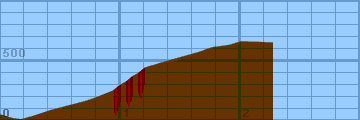
Altimeter altitude
(Altitude linearly interpolated from altimeter
samples, and smoothed with a 0.04mi gaussian.)

Each horizontal line is 100 feet. Each vertical
line is 0.2 miles. Gradiometer grade
(Grade linearly interpolated from gradiometer
samples, and smoothed with a 0.04mi gaussian.)

Each horizontal line is 2% grade. Each vertical
line is 0.2 miles. Altimeter grade
(Grade linearly interpolated from altimeter
samples, and smoothed with a 0.20mi gaussian.)

Each horizontal line is 2% grade. Each vertical
line is 0.2 miles. Comparison of grades
(Green grade is from the gradiometer, magenta grade
is from the altimeter, and white is where they
overlap.)

Each horizontal line is 2% grade. Each vertical
line is 0.2 miles.
Overall (averaging my first 20 hills),
the gradiometer grade averages 0.63 (% grade)
higher than the altimeter grade, with a standard
deviation of 4.5 (% grade per road).
This error may be due to:
-
Uneven sampling -- I take more samples when the
hill gets steep.
-
Calibration error (of the gradiometer or
altimeter).
In the end, though, I think that each individual
sample is accurate to within about 2% for that
instantaneous segment of road. My results may
not always agree with my altimeter, but they are
generally repeatable within 1%. I think that
I just need to take more samples to generate
more accurate graphs.
Raw Data:
Dist    Grade   Alti.   Location
----    -----   ------  --------
0.00    -11%    630	gate at the end of Sneath
0.10    -5%     600	cattleguard (old - mostly filled in)
0.17     0%     590	starts climbing here
0.28     8%     620	steady grade
0.43     9%     670	steady - local maximum grade
0.70     6%     740	steady - local minimum grade
0.79     8%     770	steady - local maximum grade
0.94    14%     830	getting steep now
0.96    17%     850	urk. before gentle right turn
1.00    14%     880	Hill relents briefly
1.04    16%     900	Start of long steep straight section
1.10    13%     950	middle of long steep straight section
1.14    15%     970	approaching left turn
1.20     8%    1020	after left turn -- steep over now
1.40     7%    1080	approaching eucalyptus grove - fog line
1.65     4%    1150	out in open again - wires overhead
1.76     0%    1190	end of yellow fog line - flattens
1.91     4%    1210	end of nearly-flat section
1.94    10%    1220	short bump upward - water tower
2.00    -1%    1240	flat now
2.27     0%    1230	WWII Nike missile site ruins
Back to
Lucas's
cycling gradiometer page.


