|
Products
|


|
Billy Chen, Ph.D. |
|
Last updated: 08/30/10 |
|
|
New Bing Maps Birds Eye View In November 2009, Bing Maps released a new version of Birds Eye View, which uses my idea of synthetically rendering 2.5D views from our 3D models. The idea is to create a complete isometric map of the world, which provides a natural view of building facades (like street view), but also the global context of an orthographic map. |
|
|
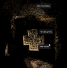
Overhead View in Photosynth The October 7th, 2009 release of Photosynth has a new navigation tool for browsing your photos! It is called Overhead view and it lets you obtain a view of your Photosynth point cloud from the sky! I have also added some new features to allow you to browse the point cloud by hovering your mouse over the points. Check it out! |
|
|
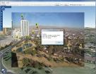
Photo Geocalibration Tool in Virtual Earth The Virtual Earth Development team has released a geocalibration tool that enables a user to calibrate photo position, orientation and focal length. This tool is based on my initial prototype in late 2007. (Sid Jain developed the Virtual Earth tool) |
|
|
Photosynth with GPS EXIF Tags In the Fall 2008 release of Photosynth, my code preserves GPS EXIF tags for geotagged synths. This is a step towards Photosynth and Virtual Earth integration. |
|
|
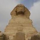
Birds Eye Image Calibration in Virtual Earth The Fall 2007 release of Microsoft Virtual Earth 3D uses my camera calibration code for showing Birds Eye images in VE3D.
In the Virtual Earth Map Control SDK v6.1, the PixelToLatLong method uses my calibration and ray-poly intersection algorithms. (Joe Schwartz helped immensely in the tech transfer)
|