Entire profile:
Description:
This is a 90.8 mile trip from the National 9 Motel in Gilroy to the Pinnacles and back. It is an annual event, run by Kevin Winterfield and his Low-Key friends. For a better description, see the 1997 MMPE webpage.If you go, you might want to remember the hours of these two frontier outposts, lest you run out of food and start eyeing those cows:
Paicines mini-mart:
	M-F 6:30am - 6:30pm
	S-S 8:30am - 6:30pm
Pinnacles campground general store:
	M-F 4pm-5pm
	S-S 9am-5pm
Altimeter grade
(Grade linearly interpolated from altimeter samples, and smoothed with a 0.20mi gaussian.)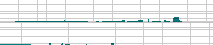
Each horizontal line is 2% grade. Each vertical line is 2.0 miles.
Altimeter altitude
(Altitude linearly interpolated from altimeter samples, and smoothed with a 0.04mi gaussian.)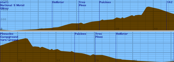
Each horizontal line is 100 feet. Each vertical line is 2.0 miles.
Raw Data:
Dist    Grade   Alti.   Location
----    -----   ------  --------
0.00	0%	 240	4:09am, AVS 17.9, Nat'l 9 Inn, (760' sofar) -MMPE-
3.19	0%	 200	L on HWY 25 towards hollister
9.4	0%	 260	on HWY 25 - begin construction
10.6	0%	 290	end construction
13.6	0%	 330	Downtown hollister, AVS 17.4
13.8	0% 	 350	5:13am, 7-11 stop
15.1	0%	 370	5:20am, Burger King in south Hollister (5:40)
17.65	0%	 520	last stopsign outside hollister
18.7	0%	 570	Best road
20.5	0%	 570	Entering Tres Pinos 6:05am
21.1	0%	 610	leaving Tres Pinos
21.8	0%	 540	bottom of hill
23.3	0%	 630	cresting
24.0	0%	 660	another rise top
25.9	0%	 700	6:33am, Paicines minimart 6:30am-6:30pm weekdays, S/S 8:30am-6:30pm, (6:50am)
26.7	0%	 770	crest
27.0	0%	 740	low point
29.48	0%	 780	approaching hill
30.4	0%	 880	cresting
31.53	0%	 830	starting another hill
31.83	0%	 890	cresting
32.3	0%	 840	low point
34.4	0%	1000	7:31am
34.91	0%	 950	low point - bridge over San Benito River
35.31	0%	1000
36.25	0%	1020
36.8	0%	1010	begin big climb
36.99	0%	1050	7:50am (stop to take off layer of clothes) (7:56)
38.2	0%	1430	top of climb
38.75	0%	1450	begin descent
41.4	0%	1330
43.4	0%	1190	turn R on entrance to pinnacles 8:27, 2400' sofar
45.36	0%	1060	turn around, gravel wipeout, 2400' sofar, AVS 15.7 8:37 - store hours: M-F 4pm-5pm, S-S 9am-5pm
47.32   0       1190
49.32   0       1330
51.97   0       1450
52.52   0       1430
53.73   0       1050
53.92   0       1010
54.47   0       1020
55.41   0       1000
55.81   0       950
56.32   0       1000
58.42   0       840
58.89   0       890
59.19   0       830
60.32   0       880
61.24   0       780
63.72   0       740
64.02   0       770
64.82   0       700
66.72   0       660
67.42   0       630
68.92   0       540
69.62   0       610
70.22   0       570
72.02   0       570
73.07   0       520
75.62   0       370
76.92   0       350
77.12   0       330
80.12   0       290
81.32   0       260
87.53   0       201
90.72   0       240
Back to Lucas's cycling gradiometer page.