Descent: 10 feet (3 m)
Description:
This road starts on Alpine Road above Arastradero, and parallels Los
Trancos Creek, which marks the border between San Mateo and Santa
Clara Counties. It starts out relatively flat, and the climbing begins
just a couple hundred yards before leaving Portola Valley city
limits. The steep section starts out around 14%, and gradually gets
steeper until it hits 18%. Then it abruptly changes to a brief section
of 7%, before resuming at a 16% grade. Shortly thereafter, the road
narrows and flattens out as it begins a series of sharp switchbacks.
Alternatively, you can turn left on Ramona, and continue climbing up
to Vista Verde.
Altimeter altitude
(Altitude linearly interpolated from altimeter
samples, and smoothed with a 0.04mi gaussian.)
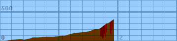
Each horizontal line is 100 feet. Each vertical
line is 0.2 miles. Gradiometer grade
(Grade linearly interpolated from gradiometer
samples, and smoothed with a 0.04mi gaussian.)
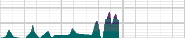
Each horizontal line is 2% grade. Each vertical
line is 0.2 miles. Altimeter grade
(Grade linearly interpolated from altimeter
samples, and smoothed with a 0.20mi gaussian.)
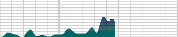
Each horizontal line is 2% grade. Each vertical
line is 0.2 miles. Comparison of grades
(Green grade is from the gradiometer, magenta grade
is from the altimeter, and white is where they
overlap.)
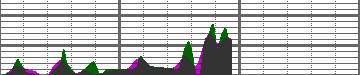
Each horizontal line is 2% grade. Each vertical
line is 0.2 miles.
Overall (averaging my first 20 hills),
the gradiometer grade averages 0.63 (% grade)
higher than the altimeter grade, with a standard
deviation of 4.5 (% grade per road).
This error may be due to:
-
Uneven sampling -- I take more samples when the
hill gets steep.
-
Calibration error (of the gradiometer or
altimeter).
In the end, though, I think that each individual
sample is accurate to within about 2% for that
instantaneous segment of road. My results may
not always agree with my altimeter, but they are
generally repeatable within 1%. I think that
I just need to take more samples to generate
more accurate graphs.
Raw Data:
Dist    Grade   Alti.   Location
----    -----   ------  --------
0.00	 0%	 460	start - Alpine Road
0.09	 1%	 460
0.14	 6%	 470
0.21	 1%	 480	Meadow Creek Ct
0.33	 0%	 490
0.37	-6%	 490
0.40	 0%	 480
0.50	 4%	 500
0.53	11%	 510
0.55	 4%	 520
0.64	 0%	 520
0.78	 5%	 530
0.83	 0%	 530
0.88	 2%	 530
1.10	 2%	 550	just past Oak Forest Ct.
1.14	 3%	 560
1.16	 7%	 570
1.24	 3%	 590
1.49	 2%	 620
1.53	 9%	 630
1.57	12%	 650
1.60	 8%	 660
1.64	-3%	 660
1.67	 2%	 660
1.70	13%	 680
1.73	12%	 700
1.75	17%	 720
1.77	17%	 730
1.79	18%	 750
1.80	 5%	 760
1.82	11%	 760
1.84	14%	 770
1.86	15%	 780
1.88	17%	 800
1.91	10%	 820
1.93	13%	 830	Ramona Road (speed limit 25 sign)
Back to
Lucas's
cycling gradiometer page.