Dan Connelly describes it well:
This is a classic, the benchmark climb in the region. It is neither terribly steep nor long, but its proximity to population centers and the beauty of its narrow switchbacks and generous shade make it extremely popular. Almost all local riders know their best times up this hill, from the bridge to the stop sign. Each Wednesday it is climbed by the infamous "Noon Ride", often including national-caliber riders. It was recently repaved over 75% of its length, making it a bit faster.
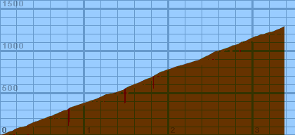
According to my measurements, the road is 3.37 miles long (from the bridge to the stop sign), and gains 1290 feet. Due to its twisting nature and constantly changing grades, the local gradiometer readings should be considered approximate. Even though I measured the grade every 30-50 yards, I still did not capture all the bumps and undulations in the climb. I did a lot of guesswork to try to pick a sample that was representative of each segment.
Overall (averaging my first 20 hills), the gradiometer grade averages 0.63 (% grade) higher than the altimeter grade, with a standard deviation of 4.5 (% grade per road). This error may be due to:
Dist    Grade   Alti.   Location
----    -----   ------  --------
0.00	 2%	 420	start - bridge (0.07mi from Portola Road)
0.02	 6%	 420
0.04	 7%	 430
0.05	10%	 430
0.06	 5%	 440
0.07	 8%	 440
0.09	 7%	 450
0.11	 7%	 460
0.13	10%	 460
0.15	 7%	 470
0.18	 8%	 490
0.21	 8%	 500
0.23	 3%	 510
0.26	 5%	 510	180-degree left turn over creek
0.28	 4%	 520
0.30	 7%	 520
0.32	 8%	 530
0.33	10%	 540
0.35	 6%	 550
0.36	 7%	 550
0.37	12%	 560	90-degree right turn
0.38	 7%	 560
0.40	 6%	 570
0.42	11%	 580
0.44	 9%	 580
0.46	 8%	 590
0.48	 6%	 600
0.50	 7%	 610
0.52	 7%	 610
0.54	 7%	 620
0.56	 9%	 630
0.58	 8%	 640
0.60	 7%	 640
0.63	 7%	 650	171 Old La Honda
0.64	 9%	 660
0.66	 7%	 670
0.68	 8%	 670
0.69	 8%	 680	Home Road
0.71	 7%	 690
0.72	11%	 690
0.73	 7%	 700
0.76	 7%	 710
0.78	10%	 710
0.80	13%	 720	right turn -- middle of right lane
0.81	 9%	 730
0.82	 6%	 740
0.85	 7%	 750
0.88	 7%	 760
0.91	 7%	 770
0.94	 8%	 780
0.97	 6%	 790
1.00	 7%	 800
1.03	 7%	 810
1.04	 9%	 810
1.06	 6%	 820
1.08	 6%	 830	start wood retaining wall on left
1.10	10%	 830
1.12	 5%	 840	end wood retaining wall
1.15	11%	 850
1.17	 8%	 860
1.19	 8%	 870
1.22	10%	 880
1.23	 3%	 890
1.25	10%	 900
1.26	 5%	 900
1.28	 9%	 900
1.30	 3%	 910
1.33	 3%	 910
1.35	 9%	 920
1.37	 9%	 920
1.39	 5%	 930
1.42	 7%	 940
1.45	 5%	 950
1.46	18%	 950	inside of right switchback
1.47	15%	 960	straightening out
1.48	 9%	 970
1.50	 8%	 980
1.54	 7%	1000
1.57	 8%	1010
1.59	 7%	1020	443 Old La Honda
1.62	 9%	1030
1.65	11%	1040
1.67	13%	1050
1.68	14%	1060	455 Old La Honda
1.69	 9%	1060
1.71	 9%	1070
1.73	 8%	1080
1.76	11%	1090
1.79	 8%	1100
1.81	 9%	1110
1.82	 6%	1120
1.86	 9%	1140	Orchard Hill Road
1.89	 8%	1160
1.91	 7%	1170	Entering redwoods
1.93	10%	1170
1.95	 9%	1180
1.97	 6%	1190
2.01	 4%	1200
2.04	 6%	1210
2.06	 9%	1220
2.09	 8%	1230
2.13	 5%	1240	roadside pens - horses, goats, etc.
2.17	 6%	1250
2.20	 9%	1260
2.23	 6%	1270
2.27	 8%	1280
2.29	11%	1290
2.30	 9%	1290	big redwood - road barely one lane wide
2.32	 5%	1300
2.34	10%	1300
2.38	 9%	1320
2.40	 6%	1330
2.42	12%	1340
2.44	 7%	1350
2.46	 9%	1360
2.47	18%	1360	inside right turn -- steep only for a few yards
2.48	 7%	1370	Martinez Road
2.50	 9%	1380
2.52	12%	1390
2.53	 8%	1400
2.55	 7%	1410
2.57	11%	1410
2.59	 9%	1420
2.61	 4%	1420	3-inch dip across the road
2.63	 8%	1430
2.66	10%	1440
2.69	 8%	1450
2.72	 6%	1460
2.74	 5%	1470
2.75	10%	1480
2.78	 3%	1480
2.80	 6%	1490	Summit Road
2.81	 5%	1490
2.83	 7%	1500
2.86	 9%	1520
2.90	 8%	1530
2.93	10%	1540
2.96	 9%	1560
2.99	 6%	1570
3.03	 7%	1590
3.05	 6%	1590
3.07	 7%	1600
3.09	 4%	1610
3.12	 9%	1610
3.14	 8%	1620
3.17	 4%	1630
3.18	 8%	1630	on right, 20-foot rock wall, with redwood on top
3.20	 2%	1640
3.22	 7%	1640
3.25	 9%	1650
3.27	 8%	1660
3.29	 5%	1670
3.30	11%	1670
3.32	13%	1680
3.34	10%	1690
3.36	10%	1700	first mailbox
3.37	 8%	1710	stop sign -- Skyline