Entire profile:
Description:
This is my usual route from the Rains houses bldg. 28 at Stanford to my parent's house in Belmont.
Altimeter grade
(Grade linearly interpolated from altimeter samples, and smoothed with a 0.20mi gaussian.)
Each horizontal line is 2% grade. Each vertical line is 1.0 miles.
Altimeter altitude
(Altitude linearly interpolated from altimeter samples, and smoothed with a 0.04mi gaussian.)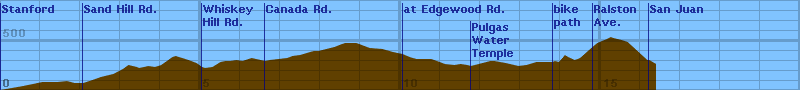
Each horizontal line is 100 feet. Each vertical line is 1.0 miles.
Raw Data:
Dist    Grade   Alti.   Location
----    -----   ------  --------
0.00	0	 80	start - Rains Houses, Stanford, 3-29-97, 5:38pm
0.14	0	 90	on Campus Drive at Bowdoin St.
0.57	0	120	at Mayfield Ave.
1.05	0	160	onto Foothill Expressway
1.43	0	160	at Campus Drive West
1.66	0	170
1.85	0	150
1.99	0	150	onto Alpine Road
2.07	0	150	onto Sand Hill Road
2.30	0	180	at Sharon Park (1st stoplight)
2.51	0	210	2nd stoplight
2.82	0	240	Saga Lane (3rd stoplight)
3.06	0	290
3.20	0	330	SLAC (4th stoplight)
3.41	0	310
3.47	0	300	stoplight at 280
3.70	0	320	overpass over 280
3.86	0	310	starting climb
4.02	0	330	Lawler Ranch Road
4.30	0	410	approaching crest
4.38	0	420	crest
4.70	0	380	descending...
4.90	0	350
5.04	0	310	onto Whiskey Hill Road
5.11	0	300	on whiskey hill
5.30	0	310	starting to climb...
5.50	0	360	flattening slightly
5.62	0	370	flat now
5.75	0	370
5.90	0	380	crest
6.05	0	370	valley
6.28	0	400	crest
6.39	0	390	onto Hwy 84
6.62	0	370	onto Canada Road
6.73	0	380	crest
7.17	0	400	at Glenwood (stopsign)
7.30	0	420
7.49	0	430
7.83	0	470
7.95	0	470	280 underpass
8.35	0	510	Jefferson Ave (climbing now)
8.54	0	540	nearing top
8.62	0	550	crest
8.79	0	550	speed limit 50mph
8.90	0	550	heading downhill
9.23	0	500
9.55	0	490	280 underpass #2
9.81	0	460	dropping...
10.05	0	440	Edgewood Road
10.23	0	410
10.31	0	400
10.40	0	390
10.77	0	390	beginning to drop
10.98	0	360
11.11	0	340	flattening
11.35	0	330	white stripe across road
11.50	0	340
11.67	0	330
11.76	0	320	at the watertemple, starting to climb
12.15	0	360	close to the top
12.25	0	370	crest
12.35	0	370
12.63	0	350
12.95	0	320	valley
13.15	0	330
13.32	0	350
13.40	0	360
13.80	0	360	onto bike path to Ralston
13.86	0	370
13.96	0	360
14.05	0	400	start overpass over 280
14.11	0	430	overpass crest
14.19	0	410	descending
14.30	0	390
14.35	0	380	valley
14.43	0	390	roller coaster mini-peak
14.49	0	400	climbing...
14.80	0	510	onto Ralston Ave
14.92	0	550	Christian Drive (stoplight)
15.16	0	590	lookout point
15.26	0	610	crest
15.32	0	600	Hallmark Drive (stoplight)
15.53	0	580	Belmont Canyon Road (stoplight)
15.68	0	560	Ralston middle school
16.17	0	380	onto Cipriani Blvd
16.22	0	380	onto San Juan Blvd
16.39	0	340	home
Back to Lucas's cycling gradiometer page.